Written by Jessica Del Bozque, Project Archaeologist at Montgomery Archaeological Consultants and graduate student at Adams State University
Hey there adventurers! My name is Jessica Del Bozque, – I’ve been working as an archaeologist in Utah since 2011 and have been a graduate student since 2021. In honor of Archaeology and Historic Preservation Month, I’d like to share some of the discoveries of my thesis research with you.
My thesis research is focused on a post-contact (post-1770s) game-drive structure that was used for the communal hunting of pronghorn that was identified and documented by Brian Meinhart, AnneMarie Brown, and me during a cultural resource survey conducted by Montgomery Archaeological Consultants in 2021. This site is named “The Hamlin Valley Trap Site” and is situated in the eastern Great Basin of western Utah on State of Utah School and Institutional Trust Lands Administration (SITLA) property within the traditional territory of the Paiute Indian Tribe of Utah. For this blog series highlighting technology in archaeology and preservation, I’d like to focus on the extensive mapping program completed at the site as part of my thesis research. But first, some background!
*DISCLAIMER: This project required specific permission from SITLA, and a Public Lands Policy Coordinating Office Archaeology Permit was obtained prior to any thesis fieldwork. Please visit all archaeological sites with respect.
Background: Communal Hunting and Game-drives in the Great Basin
Communal hunting of large game animals (such as pronghorn, mule deer, and bighorn sheep) using game-drive structures has a long history in the Great Basin. Archaeological and ethnographic evidence suggests the use of game-drive structures for communal hunting spans a broad period, from at least 5,000 years ago into the 19th century (Hockett and Dillingham 2023). Communal hunts were important regional events that drew people together once or twice a year and facilitated important social interactions between various groups of people that likely included opportunities to trade, share information, and strengthen alliances (Lubinski 1999:164; Hockett et al. 2013:77). Due to the longevity of communal hunting in the region, it has been hypothesized that within an ever-changing ecological and social landscape, the practice of communal hunting may have been one of the primary constants in the Great Basin (Hockett et al. 2013:77).
The game-drive structures used for communal hunts were meant to capture large game animals through utilizing fences to form drivelines and corrals in tandem with the surrounding topography to entrap animals for mass harvest of materials, including meat. They are a type of hunting architecture, which encompasses a suite of human-made modifications to the natural landscape that increases the yield and/or predictability of natural resources (Lemke 2021:1). These are permanent or semi-permanent structures built with the intent to aid hunting activities (Lemke 2021:1). In addition to game-drives, other types of hunting architecture include fishing weirs and hunting blinds. Most documented Great Basin examples are within the state limits of Nevada, yet a few examples have also been documented within Utah. Game-drives have several forms, though nine main shapes have been identified (Figure 1).

Pronghorn-related game-drives in the Great Basin can range from 0.45 m to 2.1 m tall while diameters of corrals can vary from 15 m to 1.6 km or greater (Raymond 1982:24; Lubinski 1999:162). Wood, rock, and brush are common construction materials with most game-drive structures constructed of juniper trees, using vertical posts, logs, and/or living trees. Pronghorn traps are distinctive compared to other large-game traps as the reluctance of pronghorn to jump vertically allows constructed walls to be relatively short (Lubinski 1999:166).
The Hamlin Valley Trap Site
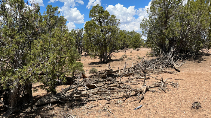
The Hamlin Valley Trap Site is a keyhole shaped game-drive structure that was used for communally hunting pronghorn. It is situated within pinyon-juniper woodland in western Utah and is constructed of juniper trees, of which most were cut with a metal-axe, indicating a post-contact (post-1770s) construction. The structure consists of a relatively small corral (20 m diameter) with two associated fences extending to the south and forming a “V”. The western fence is 100 m long while the eastern fence is about 150 m long (Figure 2). The corral consists of roughly seven charred trees that are standing or laying on the ground in a circle while the drivelines are constructed of juniper trees and branches stacked 20 – 110 cm tall. The eastern driveline has a large gap (about 55 m) that is likely a result of erosion over time. Artifacts identified at the site include two chipped stone flakes (related to stone tool manufacture) and a metal file (Figure 3), but it is unclear if these three items are related to communal hunting activities.

Intensive Mapping Program: Inspiration
As mentioned earlier, game-drives are part of a suite of hunting architecture. Fishing weirs are a similar type of hunting architecture situated in aquatic ecosystems, rather than terrestrial ecosystems, that utilize fences and entrapment features. While conducting background thesis research, I found myself fascinated by correlations between these two variations of hunting architecture. I was inspired by previous mapping efforts of fishing weirs by Peterson et al. (1994) and Greene et al. (2015), which utilized extensive plan view mapping to demonstrate the relationship between the hunting architecture and the surrounding landscape (Figure 4). This type of mapping also serves as a way to preserve the condition of the site at a specific moment in time. As a result, a similar strategy at the Hamlin Valley Trap Site was determined to be an effective tool for considering the relationship of landscape to site features at this location and also preserving the condition of the site during archaeological investigations. The Ashley National Forest’s (2015) brush fence mitigation plan was also a useful resource for site characteristics to map.

Intensive Mapping Program: Methodology
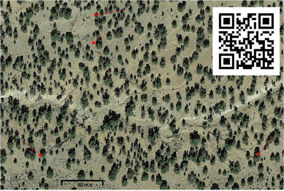
The science and art of mapping, or cartography, has a long history and varied techniques. In the fishing weir examples, mapping techniques included using a transit (an optical surveying instrument) and measuring tape as well as a Trimble GPS unit and total station (an incredibly precise survey instrument), utilizing teams of multiple people (Greene et al. 2015; Peterson et al. 1994). Since I was working on my thesis project alone, I needed a method that would allow accurate and detailed locational information while being efficient for one person to complete.
I decided to use a handheld Trimble GeoXH GPS unit, standard for cultural resource survey, to conduct the mapping at the Hamlin Valley Trap Site. The site is situated in an area that allowed accuracy of the GPS unit to stay below 1 m, which was sufficient for the planned mapping program. Mapped elements consisted of topographic features, such as washes and drainages, as well as individual components of the game-drive structure. These included axe-cut juniper trees and limbs, juniper trees axe-cut and felled in place, juniper trees used in the construction without axe-cuts, brace trees, live junipers in/near the driveline, charred trees (fallen/pushed and standing), and axe-cut stumps. Brace trees are junipers incorporated into the driveline alignments that support the fence. Live junipers are trees in or near the alignments that are not supporting parts of the fence. Junipers felled in place are axe-cut trees still spatially associated with their stumps of origin within the driveline alignments. Junipers without axe-cuts appear to be either dead trees or pushed down trees that were collected and used in construction (parts of root structures still attached). The final map was made using ArcGIS (Figure 5). Photography was taken of the various site elements to pair with the map.
Intensive Mapping Program: Summary of Results

The mapping program conducted at the Hamlin Valley Trap Site was effective and yielded useful construction data as well as resulting in a great visual representation of the site, preserving it as it appeared during archaeological investigations. The detailed mapping resulted in the identification of 88 stumps, 16 brace trees, seven live junipers, eight junipers felled in place (Figure 6), 13 charred trees (10 standing and three pushed down) (Figure 7), and 166 juniper elements used specifically in construction, including 43 trees without axe-cuts, 45 axe-cut trees, and 78 axe-cut tree limbs. A juniper with a branch removed using an axe as well as two burnt and dilapidated trees were also mapped. Overall, the quantity of stumps observed (n=88) accounts for all axe-cut materials used in the game-drive structure. As previously noted, the corral is formed entirely by charred trees with the juniper elements forming the drivelines. This may indicate that fire was used at the corral location during a communal hunt; ethnographic research indicates that sometimes fire was used to help drive the animals or to “close” the corral (Steward 1941:219-220; Stewart 1942:336; Thomas et al. 1986:267).


Before you go…
This blog covered a small facet of the technology at the disposal of archaeologists to investigate archaeological sites. Several factors play into what technology is used in various situations, including time and budget constraints, available equipment, skillset, and logistics to name a few. Part of the choice to use a handheld GPS unit was because it was what was readily available to me (thank you Montgomery Archaeological Consultants!) but also the efficiency it offered due to the portability of the device. While many archaeological sites share similarities, each site is an individual and is treated as such when it comes to archaeological work – from documentation to more intensive archaeological investigations. Thank you for stopping by and taking a little bit of time to learn about some of my thesis research at the incredible Hamlin Valley Trap Site. Happy Archaeology and Historic Preservation Month!
Thank You to Joel Boomgarden and SITLA, the Utah SHPO, the Nevada SHPO, the Public Lands Policy Coordinating Office, Montgomery Archaeological Consultants, and Adams State University – you’ve made this research possible.
References
Ashley National Forest
2015 Mitigation Treatment Plan for Brush Fences in the Berry Petroleum Development Area, Ashley National Forest, Duchesne County, Utah. Ashley National Forest Mitigation Plan # AS-14-019. USDA – U.S. Forest Service.
Greene, Nancy A., David C. McGee, and Roderick J. Heitzmann
2015 The Comox Harbour Fish Trap Complex: A Large-Scale, Technologically Sophisticated Intertidal Fishery from British Columbia. Canadian Journal of Archaeology 39:161-212.
Hockett, Bryan, and Eric Dillingham
2023 Large-Scale Traps of the Great Basin. Peopling of the Americas Publications. Texas A&M Press, College Station.
Hockett, Bryan, Cliff Creger, Beth Smith, Craig Young, James Carter, Eric Dillingham, Rachel Crews, and Evan Pellegrini
2013 Large-scale trapping features from the Great Basin, USA: The significance of leadership and communal gatherings in ancient foraging societies. Quarterly International 297:64-79.
Lemke, Ashley
2021 Literal niche construction: Built environments of hunter-gatherers and hunting architecture. Journal of Anthropological Archaeology 62:1-18.
Lubinski, Patrick M.
1999 The Communal Pronghorn Hunt: A Review of the Ethnographic and Archaeological Evidence. Journal of California and Great Basin Anthropology 21(2):158-181.
Petersen, James B., Brian S. Robinson, Daniel F. Belknap, James Stark, and Lawrence K. Kaplan
1994 An Archaic and Woodland Period Fish Weir Complex in Central Maine. Archaeology of Eastern North American 22:197-222.
Raymond, Anan
1982 Two Historic Aboriginal Game-Drive Enclosures in the Eastern Great Basin. Journal of California and Great Basin Anthropology 4(2):23-33.
Steward, Julian H.
1941 Culture Element Distributions: XIII – Nevada Shoshone. Anthropological Records 4(2):209-360. University of California Press, Berkeley and Los Angeles, California.
Stewart, Omer C.
1942 Culture Element Distributions: XVIII – Ute-Southern Paiute. Anthropological Records 6(4):231-360. University of California Press, Berkeley and Los Angeles, California.
Thomas, David Hurst., Lorann S.A. Pendleton, and Stephen Cappannari
1986 The Western Shoshone. In Handbook of North American Indians, Vol 11, Great Basin, edited by W.L. D’Azevedo, pp. 262-283. Smithsonian Institution, Washington, D.C.
Did you learn something new? Have you seen drive lines like these before? We want to hear from you! Connect with us on social media through the links below.